
LOCATION

BEACHES
TOSSA DE MAR TOWN BEACHES
Platja Gran

A different perspective of Platja Gran can be seen in the shot top of page - it is of course the first beach.

Dozens of bars/cafes/restaurants line the beach road which runs right along the back of the sand. Bigger boat superstructure in background (best seen if you click-expand) belongs to one of the coastal ferries which nose into a designated zone at the southern end of the beach. Regular smaller glass bottom boats which head into the coves to the north leave from here too.
Platja de la Mar Menuda

The beachfront esplanade continues over a low rise to this northern beach section. The cafe/bar/restaurants continue . Beach conditions are similar to the main beach - there may be better close to the beach snorkeling opportunities at the far end. Mar Menuda is the far beach in the opening shot.
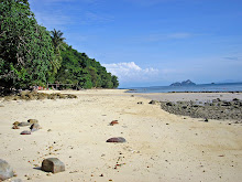
Platja Es Codolar

This lovely little spot is only abt 3 minutes walk south of the end of Pl Gran - take the street past the restaurants in the lee of the castle wall. This is a late in the day shot - my memory of earlier hours in a peak season August previous visit was that the beach was so packed that I repaired to the big rock on which this pix was shot for some sun. Time can change beaches - back then it was exclusively a stone beach. But beach sand can rebuild after storm erosion in a matter of weeks.
This is definitely the best town beach for snorkelers.

Sweet.
BEACHES NORTH OF TOSSA DE MAR

Cala Futadera
BEACHES WITHIN WALKING DISTANCE

I walked up from Tossa lower left to Cala Futadera - I've marked in the walking track: gaps mean walking the road or beaches. It's 6km from Tossa to C Futadera by road - the trekking track short cuts so I'm guessing the walk is maybe 4km. But there is a hell of a lot of verticality in in.
I forgot to do a distance scale - the straight line distance from the start of the track to C Futadera is only 2.3km
Cala Bona

This deep narrow inlet is the first you reach heading north from Tossa de Mar. The beach is that tiny bit of sand against the bar/restaurant far left. I shot this fairly early in the day on my trek north (see details down page) - on my return about 1500 the cove had a lot of moored leisure craft and the water seemed to suffer in clarity from this.
I know dozens of coves like this in Australia - but you would never be able to support a bar/restaurant at them unless they were in a city like Sydney (and yes, Sydney does have coves like this).

Cala Bona is about 3km by road north of Tossa by road. A steep track leads down from the car park. I came in on the hiking track from the south - it drops steeply into the bay. Trekkers can take the car park track to continue north or a more easterly track, the start of which is the set of steps immediately right of the restaurant/bar in my photo.
The glass bottom boats venture into the cove to stick their noses into the caves on the northern side.
I didn't put a distance scale on this image - it is only 140m in a straight line from the car park place marker to that of the hiking track, but the drop and rise is such that if you had to walk it via the restaurant it would be at least 300m, maybe more.

Naturally, at such a sweet location I just had to stop for a beer or three on the return leg of my trek.
Cala Pola

Not much more than a km past Cala Bona the main road drops steeply behind a bigger inlet which contains Cala Pola's neat little beach. Sand and water quality is pretty good. Fairly crowded because there is a surprisingly big camping area in back - pool and all.

Cala Pola at center. I've added the trekking track from Cala Bona bottom left. To continue north becomes less clear because the official trekking track with its excellent signs heads west from this beach on an inland circuit back to Tossa - northwards, the best bet is to take the path I've marked along the side of the camping area - this climbs to near the main road which is not that street around the headland at right.
The development at top right corner is the leisure area behind the next beach north, Cala Giverola (see below).
Adding a distance scale is difficult on these mulit-height images - it is 450m straight line from the pin of the main road place-marker to water's edge at the beach.
Cala Giverola

The coast road climbs/twists/drops another km to Cala Giverola. This is a pretty nice beach.
Sand and water quality pretty good. If you click/expand you may be able to see a smaller beach in background - not as nice, but fewer people and the offshore snorkeling looked more promising.

The smaller second beach is accessed via the tunnel in shot. To continue trekking north, take those steps to the right of the tunnel entrance.

Cala Giverola is the northern terminus for the glass bottom boat runs - they will drop you here for some beach time and you can jump on a later boat back to Tossa. Sweet.

I'm not sure what the best deal is for drivers - I would use the beach assess road from top left but with a guy collecting parking fees at abt the place marker, cheapskates like me would maybe park somewhere short of this.
If walking from the south as I did I suggest you also come in on this road. The shorter route from the high on the ridge Giverola Resort apartments lower-center of image (I used it on the return trip exiting the beach) is kinda tricky up near the main road - the obvious entrance (exit for me) had a locked gate, forcing me to use the higher entrance thru the resort lobby. Tip: act like you own the joint. btw if you stay here, there is a funicular type thing which makes beach access/exit easy - that track is pretty steep.
Straight line distance from the main road place-marker to track north marker is 320m.

The region behind the beach seems to be the leisure area for Giverola Resort. Apart from this pool there were tennis courts, a water slide, a huge grassed sun-lounge area, mini-golf and a nice restaurant/bar. There were a few life guard types hanging around the pool, but no security goons hassled me which suggests that people who pay the parking fee or boat ticket are free to use it. Not too many people would walk in to this beach like I did.
Cala Futadera

This lovely little beach is just around the headland nth of Cala Giverola - abt 6km from Tossa. The road is way up the top but access is easier than first appears - there is a set of steps to left of shot. The hardest part is having to wade about 15m thru thigh deep uneven-bottomed water past that rocky area at left of image (note tidal range is small on this coast so that wading would remain thigh deep most times).


....and hanging around on water craft in a sheltered cove seems to be a fine way to spend a lazy summer afternoon.

If you come by car or moto, park in the area marked on the main road. Take the smaller road which drops down the headland - it is sign-posted private which everyone ignores. When you come to the garage of a villa you will see the concrete steps starting at the left. These go steeply down the hillside to just short of the beach. A path continues to the end of the headland far right.
I came up from Cala Giverola on the "track nth" so marked. This hits the private road a short distance from the down stairway.
Straight line distance from the parking place-marker to the garage marker is 250m.
----------------------------------------------------
NORTHERN BEACHES WHICH ARE A BIT FAR TO WALK TO.

Pl de St Pol at St Feliu de Guixols

Unless you are a super keen trekker, the 4 marked beaches north of Cala Futadera need a car, moto or in my case bicycle to reach from Tossa. Straight line distance from Cala Futadera lower left to Playa Sant Pol is 10km but Google maps tells me it's over 20 on that twisting coastal road.
Cala Vallpressona/Vallpregona

At 10km from Tossa, this is some distance from Cala Futadera which is as far as I trecked. I called in on my epic bicycle ride to Sant Feliu de Guixols - 65km return on that awesomely scenic twisting/climbing/dropping coast road. There are half a dozen beach areas between my trek's end and Sant Feliu but I decided I only had time for two - Vallpressona is mentioned on naturist websites so I thought I'd drop down from the main road high above. As you can see it is a stone beach - it's about 300m long and has very clear water. There was no one on the beach when I called in. A few tents were set up in the bush behind the beach - some seemed to be long term in nature. This looks an excellent free camping area.
There is a small beach just around the far headland called Cala Concagats, which appears on Google Earth's embedded photos to be sandy, like nearby Cala Senor Ramon.

Cars should park up on the main road. The dirt access track is well signposted. I found I could ride my bicycle most of the way down to the beach and back - there were only a few parts too steep or rough for this inexperienced mountain biker. I'm not sure how a moto would go - might be a bit narrow and rough in places. Certainly inexperienced riders should walk the one km or so. Straight line distance from parking place marker to Vallperssona marker is 700m.
Cala Senor Raymon

The turn off to Senor Raymon is only a km or so past the track into Vallpresson and again is well signposted. As you can see, this one is good enough for vehicles. Those boats past the far headland are moored off Canyet De Mar - a resort area way down in a tighter bay than this.

Senor Raymon is a pretty nice beach - sand is clean although hardly white, not crowded and the water is clear. There are some big underwater rocks just offshore in the northern quarter - I took my face mask out and saw some okay fish but the scene was hardly mind-blowing.
This beach too gets mentioned on naturists websites - about half the people here were nude.

Interesting sign, but the earth didn't move for me the whole time I was on the Costa Brava. I don't think the dudes owning those clifftop villas were too put off in the planning stages.

Some people left their cars up on the main road and walked the 800m or so to the beach. A
few nosed vehicles into rare clearings alongside the track. Others drove down to the restaurant 150m short of the beach which has quite big parking areas - charges 7/4 euors cars/motos. A short not too steep path/steps leads down to the beach from behind the restaurant - marked in yellow. The track is not too rough and I found only a few short very steep sections on the way out on my bike. The first 20m from the road was paved. Note the zig-zag section closest the N symbol is not being used.
Straight line distance from c Congats place marker to Senor Raymon marker is 350m.
Platja de Sant Feliu (de Guixols)

I finally made it to Sant Feliu de Guixols which starts about 30km north of Tossa de Mar. It is bigger than I expected and considerably larger than Tossa, maybe because it has a marina which can take a lot of boats, some quite big. The marina is located at the far end of this beach.
The town beach above is pretty nice without being mind blowing. It has the full range of facilities. A nice pedestrianised street runs along in back with the usual cafes/restaurants/bars/shops.
For some reason sea water in the whole St Feiu area was not as clear as at other places - I'd just come down from a high headland road behind camera; the adjacent sea looked interesting for snorkeling with big underwater rocks etc but the water wasn't the crystal clear stuff I'd seen in similar areas; eg immediately south of very busy Llorett de Mar to Tossa's south - neither was it at the beach above or further north at Pl de St Pol
Platja de Sant Pol

I pedalled over a steepish headland to this slightly longer/busier but otherwise similar beach. The area is known as St Agara and I'm not sure if it is officially part of St Feliu or a separate part of the urban ribbon which goes several km further up the coast. Certainly the hotels/resorts here claim they are in St Feliu on the booking sites.

I decided to grab a cold beer or three in one of the restaurants across the road from the southern end of the beach, and parked my rental-fanger alongside the boardwalk which runs the full length of the beach. Good bike - the least expensive I could find at Jimbo Bikes in Tossa but comfy and in good condition. Note the long seat post - I mainly hire bikes in Asia where this is never the case. The seat itself was more streamlined than my Ibiza bizza but I didn't end up saddle sore like there - maybe my nether regions were broken in. Stop that homophobic sniggering.
Lower-end mountain bikes are pretty heavy and it was not ideal for some of the long steep up-slopes on the coastal road - lotsa lycra-louts training on very flash carbon fiber racing bikes shot past me there - but the weight made it a missile on the downslopes: however the beaded edges of the tyre treads (presumably for soft surface traction) made things pretty squirrelly in a warp-speed downhill corner, not a good place to attempt to overtake a lycra-lout on the outside.
I wasn't overwhelmed by the strip of restaurants. Prices were considerably higher than at Tossa in what I considered joints located with poor sight-lines of a beach with considerably less cachet than Tossa's. Not to mention a mediocre passing parade which is important for a lone-traveller people/flash car/hot bike watcher like me. The waiters had a condescending air as if the pavement tables were too good for hoi-polloi bicyclists yet they spent a lot of their time running out to some spivvy looking dude in a beat up Renault parked in a side-lane and handing him money - probably the local SP bookie. Classy.

The size of the marina can be seen on this image. St Feliu The place has an old town with narrow streets, a medieval monastery and of course a full range of services including many accommodation options. Straight line distance from the marker at Pl St Fel to Pl St Pol's is 1700m.
----------------------------------------
BEACHES SOUTH OF TOSSA DE MAR
Cala den Carlos

At the end of a scenic 3km walk from Tossa (see Trekking down page) you come to this view from the grounds of Apartamentos Cala Llevado. There are 5 beaches down there - you can see Cala den Carlos. Hidden just around the small headland is tiny Cala Figeures. The beach closer background is the southern extension of Cala Llevado known as Cala Llorell. Tucked against the headland far background is Cala Portopi aka Porto Pi. I never made it to the last two - thing is you have to head way up to about the height of this shot and then down again for access and as usual I was time-deficient. I kinda think Portopi can only be accessed by a funicular from whatever apartments are up top. Certainly looked that way from a passing ferry. Please post in if I'm wrong.
The above is the only pic I have of Cala den Carlos - I'm not sure why I didn't take more when down there. I visited the afternoon of my arrival from Barcelona and promised myself to return to this lovely area and explore it more fully but there are so many other good spots in the greater Tossa region I didn't make it. But I saw enough to assure you this 125m long and not narrow beach has clean sand and water and an okay kiosk in back. It seemed pretty popular.

I shot this with a bit of telephoto from the same spot - the bay seemed a popular rendezvous for daytrip party boats out of Tossa. Could hear the music from my location. Looks like fun.
Cala Figeures/Figeura.

This tiny strip of sand is the area's nudist beach. As usual there was no shortage of textiles. Lovely place - I really like these small beaches with high forested headlands and sparkling clear water. It was more crowded when I visited than in this shot which I had to pinch from Panoramio-Dani Gianani

Accessing these beaches from the high arrival point at the end of the track from Tossa (it meets a road near the rear of the apartments' supermarket) is a bit tricky. I found the best way was to walk down thru the apartment area (marked yellow) - the final descent is by a steep set of steps under the Ll of C Llevado after which you follow the paved track above the rocks to Cala den Carlos. I also checked the road at far right but it had a zig-zag making it longer. There appeared to be limited parking opportunities along this road.
The rocks between the two beaches had a paved path.
I exited by a set of steps behind Cala Figeures which lead up into Camping Llevado's huge camping/bungalow area. I think this extends way up to the main coastal road many hundreds meters out of frame. There is a bunch of other accommodation providers in the general area.
Lloret de Mar

Lloret is a largish package location place about 10km south of Tossa. Many people don't like such places but Lloret is much more attractive than even bigger Blanes further down the coast. Lloret has all the usual big place advantages of good shopping, many competitive bars/restaurants and bulk accommodation to choose from plus it also has an old town, two medieval castles on the headlands each end and the reasonably nice main beach in shot. Sure it gets crowded in high season, but it has okay sand and water and lots of services like life-guards and beach/water sports. Brits and Germans have always flocked here but in July 2014 there were lots of Russian visitors. As usual the girls were gorgeous and the big beefy blokes good value.

What really appealed to me about Lloret were the areas at the ends of the beach. Here in the south we have some rocky pools with deep clear water....

....which is continues behind the camera. This area is known as Cala Banys. Cala means "creek" so I guess you don't have to have sand, not that there is much of a creek in dry season. Click expand to see the walkway which goes across to the restaurant in background. From here you can take a path uphill thru those trees to a 12th century castle, the top of which can also be seen on the click-expand. From there paths, then stairs descend to the next beach, Cala Fenals.
.jpg)
The north end of Lloret beach is likewise attractive. The sand is least crowded here, the castle doesn't look shabby and the rocky headland has a number of similar clear water pools and even a few sandy coves - the first Sa Caleta is probably the nicest and is hiidden from the camera - more are around the corner. You can hike around there on a path above the sea - if you click-expand you may be able to see people walking below the castle. This path goes for several km, often rising and falling precipitously, to Cala Canyels, except that a landslip halfway had blocked it when I walked. Which was bad luck because I was trying to catch the last ferry from Canyels back to Tossa.

The nicest way to access Lloret and nearby beaches is by the DofiJet fast ferry out of Tossa. It is more expensive than the bus but the views along the way are great, from unsettled cliffs to....

....fugitive Wall St bond traders' villas.
Some DofiJet services run half way to Barcelona. A few people choose to make the complete trip by catching the ferry to Blanes, the bus up to the rail station and then one of the frequent trains to Barcelona. These run along the coast directlybehind a dozen+ nice beaches.
The bus service out of Tossa to Lloret is fairly frequent and way less expensive than the ferry. Time taken is about the same except that in peak season Lloret itself can get some horrific traffic, making the last km or so very slow.
Cala Boadella

This secluded beach is the second south of Lloret, between the two ferry stop beaches of Pl Fenals and Pl St Cristina. This was my favourite beach in the Tossa region maybe because it is clothing optional on top of being so attractive. It also has a relaxed, friendly atmosphere. Nudists seemed to confine themselves past the big rock in the background - the beach there is just as big as this side. There is also a tiny patch of sand 20m around the rocks at the very far end where wading in waist deep water was needed,
As usual as many textiles were in the "nude" area as naturists - it's great that there is no pressure to conform to the norm on Spanish beaches.
C Boadella sand was the usual slightly coarse-grained yellow brown stuff, quite clean as was the water. For a secluded place services are pretty good with lifegaurds/first aid/beach showers and a restaurant/bar.

Access to C Boadella is along a dirt path off Av Boedella. The closest ferry stop is Pl Fenals and you can access from the south end of that beach or the center (see map down page). The Pl St Cristina ferry stop is further south - don't try to rock-hop around the headland (see below). Make sure you take the Av Boadella exit from the roundabout at top - not the road into (I think) the Botanic Gardens.
If you type "Av Boedella Lloret" into Google Maps, street view will take you down the Avenue and show the entrance to the dirt track to the beach. Google Maps does this for all of the secluded beaches on this page.
If you type "Av Boedella Lloret" into Google Maps, street view will take you down the Avenue and show the entrance to the dirt track to the beach. Google Maps does this for all of the secluded beaches on this page.
Platja Sant Cristina

This 500m long beach is only a few km and two ferry stops south of Lloret. This would be a nice beach for people seeking a quieter location - it has a full range of services and there is no shortage of holiday accommodation in the area.
Warning - if you decide to head to Cala Boedella immediately north for some skinny dipping, don't try rock hopping around the far headland. The first 80% is fine but I then had to do some rather dodgy cliff climbing. A safer way to get to Boedella is via inland streets - see map down page. It is longer in distance but I doubt longer in time. Note - take the beach exit from near the camera - I found exits blocked near the far end.
Cala Treumal

I was going to call this Pl St Cristina South until I found this southern extension had its own name.
ACCESSING THE LLORET AREA BEACHES

If you come from Tossa, all the above beaches bar C Boedella are easily reached on the DofiJet ferry. If heading for Boadella the best bet is Fenals - the route from beach central is shortest, the one from beach south maybe easier to follow. On a second visit I caught a bus from Tossa into Lloret bus station top right (has a real good info office with lotsa maps etc), walked down the main drag to the southern end of the beach, took the headland walkway to the castle, went down to Fenals and across to Boedella.
There are also local buses which can take you from Lloret to Fenals and St Cristina, but trust me, the walk along here is good value if you are not pushed for time.
------------------------------------------------------------
TOSSA DE MAR THE TOWN

Tossa is a compact little town but big enough to have a full range of services. Its 3 good beaches, castle/walled town, old quarter, good accommodation and very scenic nearby coastline make it my favourite destination in Spain.

Tossa de Mar is pretty compact - it is only 1400m in a straight line from the "to motorway" marker top left to "castle/wt marker lower right. I should have made the former "to motorway/Girona". All 3 major routes out of town meet at a central roundabout near the "supermart" symbol. The bus station is a few blocks west and there is a very good tourist information office adjacent.
Pensio Codolar was my accommodation, at the southern end of the old town (which is not as old as the walled town within the castle walls).
I haven't labelled the beaches to keep things simple - Platja Gran is obvious as is the northern Platja Mar Menuda. Tiny Platja Es Codolar is in that narrow inlet at the bottom of image.

One of the less energetic ways of seeing the town highlights is to jump on the "tourist train" here seen on the beachfront promenade. I later saw it winding its way up to the lighthouse at the very top of the castle area.

Tossa had the best old town** I encountered on this visit to Spain - only Ibiza came close. Lotsa narrow streets with bulk restaurants and bars plus shops of all types and a few funky clubs. Above is a wider than normal concourse alongside the castle walls - the restaurants here were super-competitive with their daily set specials (a choice within) which I thought good value for such an attractive place. The whole old town dining scene was similar.
** the old town is not the very very old walled town up within the castle area. This aint exactly shabby either - see below.
THE CASTLE/WALLED TOWN (VILA VELLA).

From the beach.

From the viewpoint on the Tossa to Cala Llevado trek.
The fort and walled town are mainly in the left half of this image - the higher area at right is within the castle walls, was once part of the fortifications, and now contains the lighthouse and adjacent restaurant (killer views to the south) and museum. The deep gorge containing lovely little Platja Es Codolar is between these places and the camera.
Fortifications


The really old walled town


No shortage of restaurants in the walled town. Also galleries, museums, a chapel and quite a few touristy and arty shops. Plus of course old houses - plenty of people still live here.

Dining on Platja es Codolar - shot from the castle walls.
PENSIO CODOLAR

Pensio Fonda Codolar has a sweet roof terrace - nice place to relax late afternoon.
It's located on one of the narrow pedestrian lanes
in the old part of town (look for the "Fonda" nameplate) only a stone throw from 2 beaches and the castle. Lots
of bar/restaurants and shops nearby. The owner and staff are lovely people and
perform their job very well. The English owner has lived in Tossa 40 years and is fluent in about a half dozen languages - she was very good at engendering a homely, welcome atmosphere. My room was comfortable and the outside bathroom fine. Breakfast was simple but filling.
Criticisms: although in a quiet area with little restaurant/bar noise and no traffic,
someone should have a word to the street cleaner who starts banging bins around
0430. The wifi was good in the lobby but didn't extend to my room.
--------------------------------------------------------------------------------
TREKKING
There are some fine treks out of Tossa and in the general area. Go to the tourist info office adjacent the bus stop (there is another down near the beach) and grab one of their hiking guides in a number of languages. I didn't try to cover everything there, ignoring some and short-cutting others. Below are some of the walks I did.
TOSSA TO CALA D'EN CARLOS/FIGUERS/LLEVADO

Look for the trekking signs facing uphill 30m in from Es Codolar Beach. This heads up through town and in a short time you will find yourself climbing a fairly steep cliffside path where you can get views like the 7th image on this page (way up top) of Es Codolar Bay/the castle-walled town and beyound.
Another few minutes climbing gets you to a series of viewpoints (I only had room to label one) for even more panoramic views like this page's opening shot ....and the one below.

Once past the viewpoints look for a dirt road nearby on the right (I have small blue markers showing start and finish of road) and cross to it immediately - the smaller track had me blundering about in the bush way south of where I should have been. The dirt road tends to stick fairly closely to the power lines. I saw a couple of camper vans up here - you can access the dirt road from town via another route I've only partially shown.
There are a lot of side tracks along the way - mostly the correct rout is sign-posted but if in doubt stick to the track which looks most used. Some fairly wide paths dive southwards towards the ocean - but keep heading west until near the end. There is no ambiguity there.
The track ends at a road behind the supermarket of one of the accommodation places at the beaches - refer to the map in the Cala Figueres/Figuera section about 60% down this page for details of how to get down to the sand.
Total distance beach to beach is a little over 3km (straight line distance from power line marker to viewpoint marker is 550m). It took me about 70 minutes not hurrying. Surfaces reasonably good but I would not wear flip flops. Mountain bikers may find each end tricky but there are other accesses and exits to the dirt road. Walking gradients a bit steep each end but if less fit people take rest stops only circumference-enhanced dudes will find it tough.
I URGE EVERYONE TO DO THE FIRST 10 TO 15 MINUTES TO THE VIEWPOINTS FOR FABULOUS TOWN/CASTLE/COASTAL VIEWS.
TOSSA TO CALA BONA/POLA/GIVROLA/FUTADERA

I've repeated this image to save you scrolling up page too often. Once again gaps represent highway or beach sections.
The walk is about 4km and took me about 2 hours each way. You could one-way it by using the glass bottom boat Tossa-Giverola. Surfaces are reasonably good but once again leave the flip-flops at home. The track is not suitable for mountain bikes - narrow/rough/stairs. For walkers there are some pretty good slopes making big changes in elevation but but none I'd class as heartbreakers for fit dudes.
Straight line distance from Cala Bona to Cala Futadera is only 1.2km.

Finding the start of the track out of Tossa is pretty easy - take Av Mar Menuda from the beach of the same name - this heads uphill. At the hairpin......

....take the paved path which looks like someone's driveway. This soon turns to a dirt track which heads uphill and in less than 10 minutes hits the road a short distance below the viewpoint back over the town.

Sweet outlook.
ONCE AGAIN I URGE ALL VISITORS TO TOSSA TO MAKE THE EFFORT TO GET UP HERE EVEN IF THEY GO NO FURTHER. THE CLIMB SHOULD TROUBLE NO ONE BUT THE VERY UNFIT IF PEOPLE ARE PREPARED TO TAKE A FEW REST STOPS.
Of course you can also drive or ride a moto up here - the viewpoint seemed very popular with passing motorists. The walk along the road from central roundabout near the bus station and supermarket is longer but less steep.
Only a short distance past the viewpoint is the driveway to a cliff top villa. Just past this look for the sign posted track leading off to the right.

This track runs along the ridge high above the sea until you come to the fabulous outlook below.

Click-expand to see the glass bottom boat heading out of Cala Bona's inlet. It has just nosed into that cave for a look see. The inlet close by it is heading for is Cala Pola. That high headland with the construction crane is between Pola and Cala Giverola. Lots of flash resort and other holiday apartments up there.
Thing is you are going to drop down into the first inlet, trek up to road level on the other side, drop down into Cala Pola and then trek up over the slightly lower inland side of the far headland. As I said up page, some pretty good verticality on this trek.
I'll also repeat that sign-posting is good as far as Cala Pola where the official trekking track turns inland. For details of the track past there and for getting into and out of all these bays, check my individual maps up-page (starting about 15% from the top of the page).
OTHER TREKS
I found the walk from Lloret de Mar bus station (alternatively you could start at the ferry stop on the beach) south to Cala Fenals/Boedella/St Cristina a nice one. If you don't want to backtrack you could catch the ferry from Cristina back to Tossa.
 11th century Sant Joan's castle between Platjas Lloret and Fenals. Check the map up page - the route I took went right by the castle.
Another nice one in the Lloret area is northward along the cliff path towards Cala Canyels. Even if it is still blocked you have covered a nice section - it sure was busy when I strolled along.
 Cliff walkway under Castell d'en Platja, south Lloret.
If you are tempted to take the detour at the landslip up the stairs into the hopelessly winding streets above, make sure you take a photo of the route shown on the detour sign - I found no signs up the top and spent 90 minutes weaving along streets, bush bashing across scrubby gullies and jumping 2m high fences. In the end, knowing I'd missed the last ferry from Cala Canyels, I gave up, walked out to the main coast road and hitch-hiked back to Tossa.
 LOST!
LOST!
OTHER TREKS
I found the walk from Lloret de Mar bus station (alternatively you could start at the ferry stop on the beach) south to Cala Fenals/Boedella/St Cristina a nice one. If you don't want to backtrack you could catch the ferry from Cristina back to Tossa.
Another nice one in the Lloret area is northward along the cliff path towards Cala Canyels. Even if it is still blocked you have covered a nice section - it sure was busy when I strolled along.
If you are tempted to take the detour at the landslip up the stairs into the hopelessly winding streets above, make sure you take a photo of the route shown on the detour sign - I found no signs up the top and spent 90 minutes weaving along streets, bush bashing across scrubby gullies and jumping 2m high fences. In the end, knowing I'd missed the last ferry from Cala Canyels, I gave up, walked out to the main coast road and hitch-hiked back to Tossa.
BACK TO THE INDEX
IF YOU SEE MISTAKES OR HAVE EXTRA INFO PLEASE POST BELOW. BUT IF YOU HAVE QUESTIONS PLEASE POST THEM IN THE FORUM WHICH I CHECK MOST DAYS - I RARELY RETURN TO THESE INDIVIDUAL LOCATION PAGES.


.jpg)


No comments:
Post a Comment